City Council traffic briefing
Exit 88 Crash Risk
Late-March and April police reports show a concentrated crash pattern around the I-49 / AR-72 overpass, Maverik, Casey's, and East Central Avenue.
Key numbers
The recent window stands out inside the past year
31crashes since Mar 242.58x the prior 35-day count
20since Apr 13mid-April cluster
28multi-vehicleturning/merging conflict signal
170past-year focus crashesMay 13, 2025 through May 13, 2026
Year-over-year hotspot scan
The worst YTD increases are not only at Exit 88
The scan compares Jan 1, 2026 through May 13, 2026 with Jan 1, 2025 through May 13, 2025 in 0.2-mile circles.
| Area | 2026 | 2025 | Increase | p |
|---|
| NW Tiger |
6 |
0 |
+6 |
0.016 |
| NW 3rd |
10 |
2 |
+8 |
0.019 |
| I-49 / E Central |
19 |
8 |
+11 |
0.026 |
| E Central east |
10 |
3 |
+7 |
0.046 |
| SE G |
4 |
0 |
+4 |
0.062 |
Trend
Weekly counts jumped in April after a full-year baseline
This is not a citywide average problem. It is a localized conflict-point problem near the overpass, Maverik, Casey's, and East Central.
Maverik / Casey's / East Central
A repeated multi-vehicle hotspot east of I-49
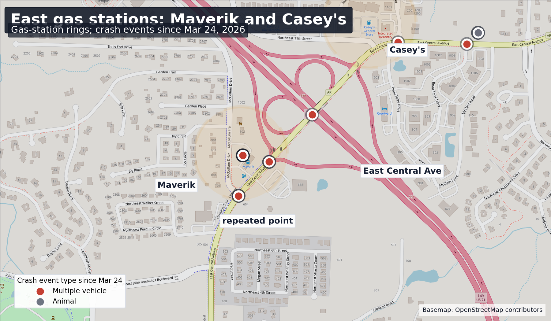
Within 0.2 miles of the Maverik / East Central repeated crash point, the past year shows 38 police-reported crashes.
11crashes since Mar 2411 multi-vehicle
9since Apr 13tight recent concentration
West approach
The west side of the overpass also needs review
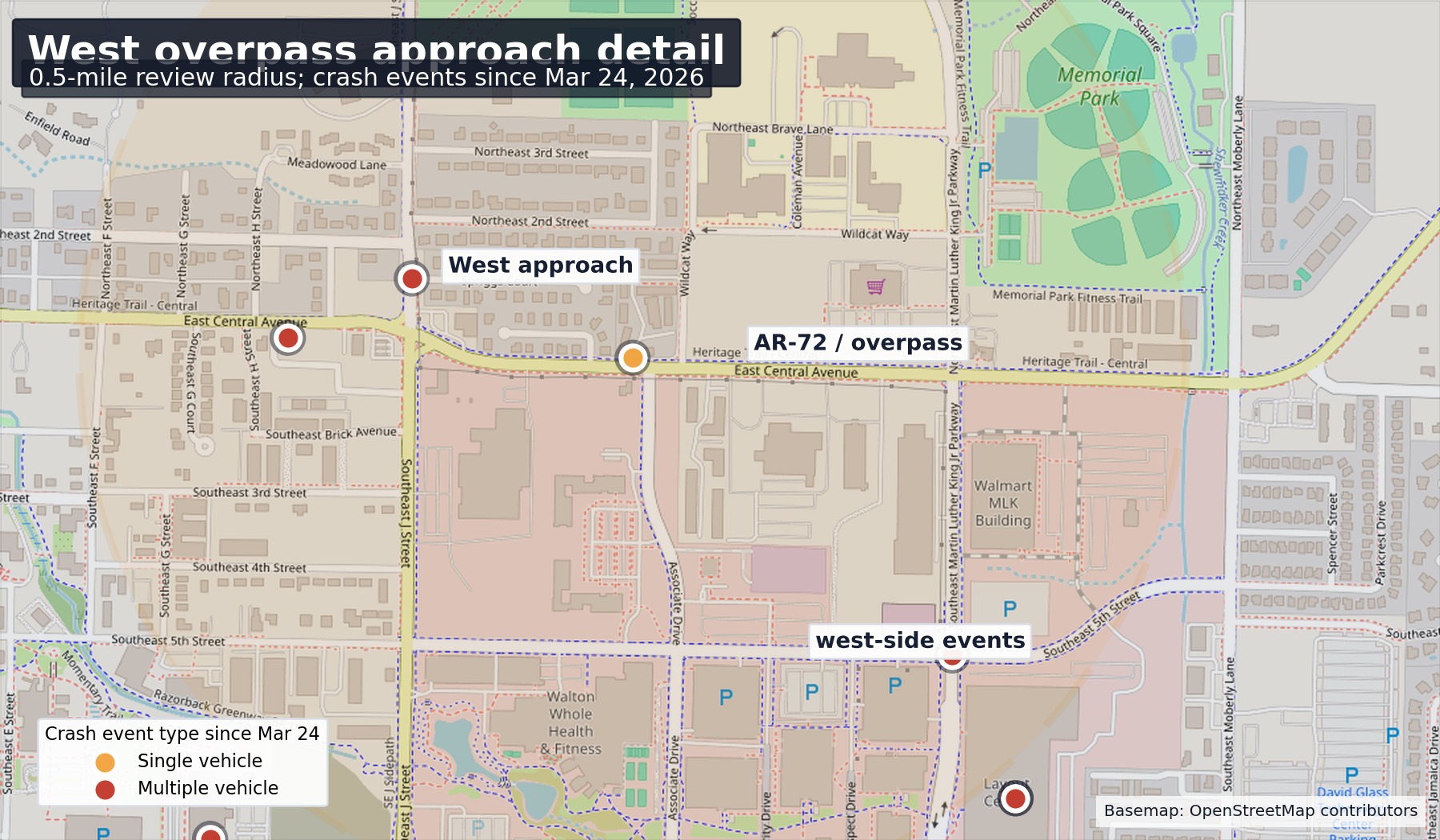
The west-overpass approach registered 36 police-reported crashes in the past year within 0.5 miles.
Since Mar 24, it has 6 crashes, including 5 multi-vehicle crashes.
That is the receiving side for added truck movements and should be included in any traffic operations review.
Crash type
Recent reports are overwhelmingly multi-vehicle
Multi-vehicle crashes are the clearest signal for intersection and driveway conflict, especially where heavy vehicles are entering or exiting mixed traffic.
The data does not prove dump-truck causation. It does show that this corridor is already operating with recent crash pressure.
Recommended ask
Do not treat added dump-truck traffic as routine
Require a truck movement planDocument haul route, exit path, peak-hour restrictions, staging, and turning controls before expanded use.
Collect short-duration evidenceUse camera counts or field observation at Maverik, Casey's, East Central, and the west-overpass approach during haul periods.
Deploy temporary mitigationEvaluate signage, enforcement, flagging, and temporary channelization while the recent crash cluster is investigated.
Data limits
Use the claim the data can support
This repository contains police transparency portal crash records. The current site exports both recent and past-year mapped focus-area points. It does not include unreported crashes, near misses, injury severity, or vehicle class fields for dump trucks.
The defensible Council message is: police-reported crashes have recently clustered around the exact corridor where added heavy-truck exit movements would increase turning and merging conflicts.
Past-year window: May 13, 2025 through May 13, 2026. Latest citywide accident record in this refresh: May 13, 2026 1:59 AM.
Appendix
Recent focus-area records
| Date | Category | Coordinates | Ticket IDs |
|---|
| May 12, 2026 12:22 PM |
2 Multiple vehicle |
36.379211, -94.178036 |
29740 |
| May 11, 2026 4:13 PM |
2 Multiple vehicle |
36.377188, -94.178979 |
29746 |
| May 9, 2026 10:33 AM |
2 Multiple vehicle |
36.377894, -94.176560 |
29731 |
| May 7, 2026 2:30 PM |
2 Multiple vehicle |
36.383331, -94.173244 |
29720 |
| May 4, 2026 3:34 PM |
2 Multiple vehicle |
36.373597, -94.187804 |
29713 |
| May 2, 2026 1:29 PM |
2 Multiple vehicle |
36.371704, -94.196898 |
29697 |
| Apr 28, 2026 6:15 AM |
3 Animal |
36.383780, -94.169706 |
29659 |
| Apr 26, 2026 5:47 PM |
2 Multiple vehicle |
36.380162, -94.176971 |
29682 |
| Apr 25, 2026 8:55 PM |
2 Multiple vehicle |
36.380162, -94.176971 |
29691 |
| Apr 23, 2026 2:10 PM |
2 Multiple vehicle |
36.379208, -94.178036 |
29686 |


